There are thousands of hiking trails in British Columbia, so I wanted to share a list of hikes that would be a nice place to start. I’ve hiked these trails several times, some even nearly 10 times, so take this as my list of the must-do hikes in British Columbia from a local, aka me!
All of the following hikes are in Southwest BC, within a few hours’ driving distance from Vancouver, which is great if you’re visiting.
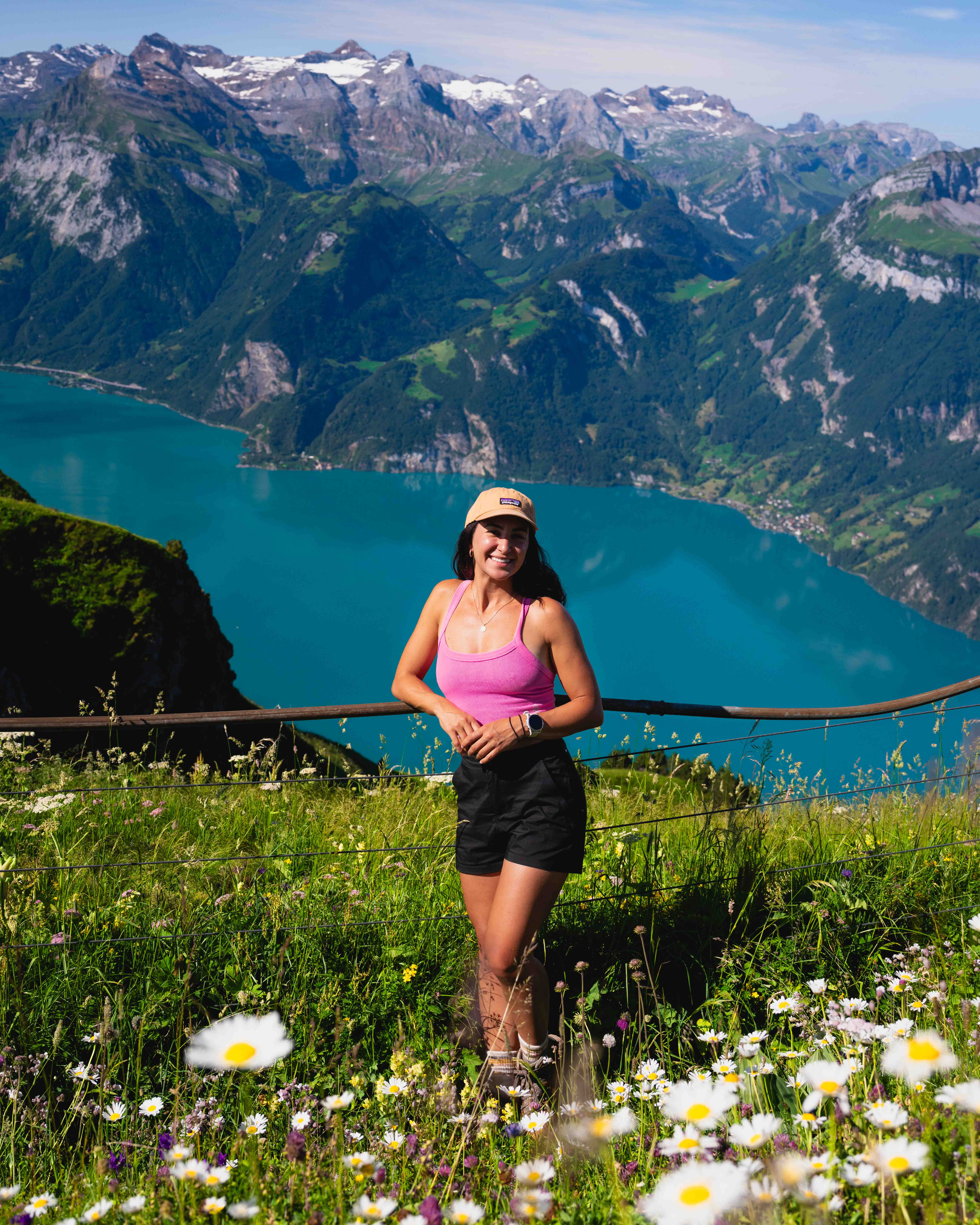
A note from Angela..
There are affiliate links in this post — A Local’s Guide to the Must-Do Hikes in British Columbia — and I may earn a small commission if you choose to purchase an item (at no additional cost to you). These funds go right back into creating free content just like this. Thank you for your support!

Read This Before You Hike
David Attenborough has said, “No one will protect what they don’t care about, and no one will care about what they have never experienced” and I couldn’t agree more.
While there’s no doubt that social media, specifically Instagram, has led to certain outdoor spots being negatively impacted (overcrowded, vandalized, trashed, etc.), I choose to believe that social media, and the internet in general, can be a place where education and environmentalism can thrive.
Online resources that include more information than just a geotag, like this blog post, allow for the outdoors to become more accessible, inclusive, and diverse.
When visiting these spots, following the Leave No Trace Principles is crucial to minimizing impacts when recreating outside. The principles are seven things that will help preserve the environment for generations to come.
Plan ahead and prepare. Make sure to check the weather, trail stats, conditions, and if there are any closures. BC hikes are tough, so you need to be prepared with enough water, food, layers, safety equipment, and know where you are going.
Travel and camp on durable surfaces. All these hikes in Southwest BC are really busy and popular, so imagine if everyone went off-trail. It wouldn’t be good for our beautiful, yet delicate, environment.
Dispose of waste properly: Whatever you bring in, you pack out. Yes, even banana and orange peels. Use the washroom before you hit the trail. If the urge hits on trail, wait for an outhouse or go out in nature, but remember to dig a hole away from water sources, do your business, cover it, and do not leave toilet paper. I bring a little bag with me for this case.
Leave what you find. Don’t pick wildflowers, don’t keep rocks, etc.
Minimize campfire impacts: You can’t have campfires on these trails so this doesn’t apply here.
Respect wildlife: BC is home to bears, marmots, and other alpine critters. Remember to give them space, do not feed them, and make a lot of noise so they don’t get surprised. Remember, you’re in their home.
Be considerate of other visitors: These trails can become very busy during the summer, so please be kind, yield to uphill hikers, refrain from loud noises or music, and let faster hikers pass
If you’d like to learn more, which I hope that you do, take a couple of minutes to read this.

What to Pack
Now that you know how to act in the outdoors, thanks to the LNT principles, let’s make sure you know what to bring to be prepared!
You don’t need new, top-of-the-line, pretty, or trendy gear… you just need gear that works. Below are some of my must-haves for these hikes.


Must-Do Hikes In British Columbia
Know that a lot of BC hiking is tough. Steep and relentless trails. No service. So please be prepared when adventuring out in these beautiful places.
The following trails are in no particular order. Let’s get into it!
1. Panorama Ridge
Let’s start out strong with Panorama Ridge, one of the most iconic hikes in British Columbia.
I have done this hike almost every year for the last decade. It’s a special one and worth every step, but it is a tough and long day, so be ready. No matter how fit I may feel at the time, this trail humbles me, and I’m always limping the last few kms back to the car.
If you aren’t ready to take on this 30km hike, start by hiking to Garibaldi Lake first, which is along this trail. It’s still a tough one!
You need a day-use permit to access Panorama Ridge (and Garibaldi Lake). You can get one here. You’ll need one if you’re visiting from May to October. If you have a valid reservation for overnight camping, you do not need a day-use pass.
There are two trailheads for Panorama Ridge—one is the Garibaldi Lake/Rubble Creek trailhead, which is the most popular, and the other is the Cheakamus Lake trailhead.
After doing this hike from both trails, I prefer the Cheakamus Lake trailhead because it’s just as scenic, you’ll see a fraction of the people, and it feels like the elevation seems a bit easier. If you’ve done the ‘endless’ switchbacks on the other trail, you know how tough they are.
That said, if you want to visit Garibaldi Lake on the way to Panorama Ridge (there is a slight detour so it’ll make your hike longer), you’ll need to start at the Garibaldi Lake/Rubble Creek trailhead.
Since this is a long day hike, you can camp at several campgrounds in the park to break it up. There are Garibaldi Lake, Taylor Meadows, and Helm Creek campgrounds. You need to reserve in advance here on the BC Parks website.
Trail stats: Length: 30.3km (round trip) | Elevation Gain: 1,569m
See all info on the trail (including offline map): HERE


Photo Tip: I love all times of day here. Sunrise usually has soft light, mid-day is vibrant colors, and sunset has beautiful orange side light. So, you really can’t go wrong. I also prefer going either in early summer or late summer, so there’s more snow on the peaks.
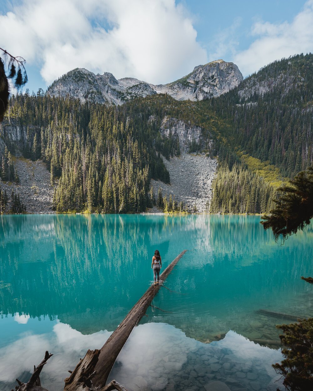
2. Joffre Lakes
This trail is a BC classic and will bring you to three spectacular lakes—Lower, Middle, and Upper Joffre Lakes. Get ready to be mind-blown by the towering mountains and vibrant turquoise-coloured water at all three.
You need a day-use permit to access Joffre Lakes. You can get one here. You’ll need one if you’re visiting from May to October. If you have a valid reservation for overnight camping, you do not need a day-use pass.
The color of the water is due to the glacial silt that comes from the surrounding glaciers. The trail is open all year round, which makes this provincial park both a summer and winter destination.
If you’re brave enough, you could take a dip in the water in the summer months (but be warned… the water is very, very cold).
With it being a popular trail, it can get very busy, so I’d try and go on a weekday, if you can.
If you want to extend this hike, I suggest going to the third lake and following the trail to the campground at the other side of the lake. Then, find the trail that heads up the hill a bit to get a view over the lake!
If you’re keen on camping, check out the ‘Reservations’ section of the BC Parks website to snag a permit. Campsites are situated at Upper Joffre Lake and are epic. This was my very first backpacking trip, so it holds a special place!
Trail stats: Length: 7.1km (round trip to third lake) | Elevation gain: 478m
See all info on the trail (including offline map): HERE


Photo Tip: Walking out on the log at the second lake has become a quintessential photo to get. If you don’t want to go for a swim, be careful when walking out there. It’s really slippery!
3. Saint Mark’s Summit
This is another classic hike in the Vancouver area is located on Cypress Mountain.
The well-marked trail will lead you to some of the most epic views of Howe Sound. There is a lot of parking as it starts at the ski resort, which is great, especially if you’re hiking with friends.
This trail gains elevation steadily, so don’t underestimate the difficulty. It can get busy, so I’d hike mid-week if you can.
There are a lot of deadly drop-offs (near and) at the top of the trail, so be mindful of your footing and keep a safe distance from the edge.
Trail stats: Length: 10.1km (round trip) | Elevation Gain: 567m
See all info on the trail (including offline map): HERE
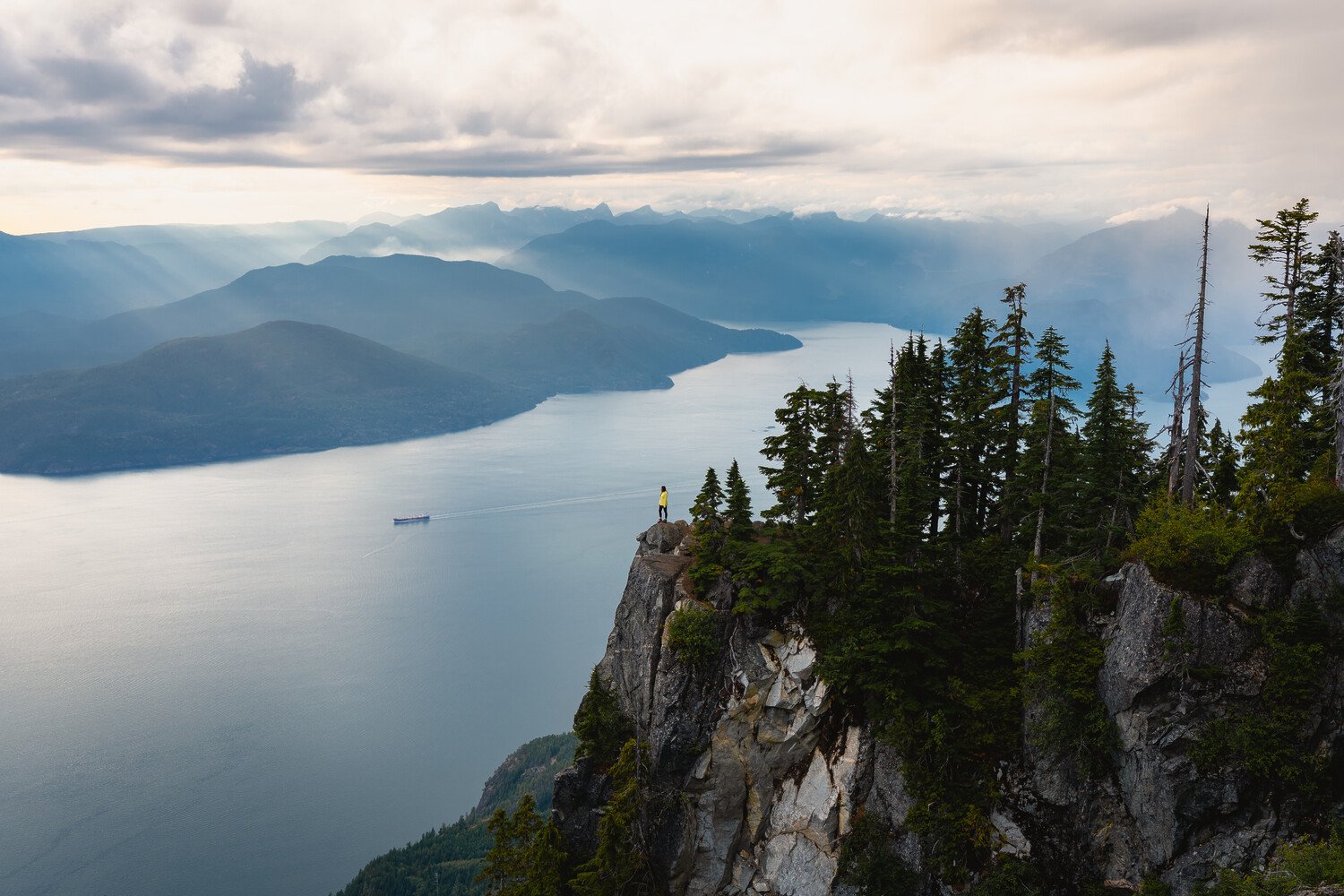
Photo Tip: Sunset is absolutely the move up here as it always sets along Howe Sound.
4. Golden Ears
This hike is iconic and is absolutely one of the must-do hikes in British Columbia.
Unfortunately for us, though, it is a grind to get to! The trail has a lot of exposed roots and is very steep and long, so be prepared.
You need a day-use permit to access Golden Ears. You can get one here. You’ll need one if you’re visiting from May to October. If you have a valid reservation for overnight camping, you do not need a day-use pass.
There are tent pants just below the summit if you want to camp up here. They are claimed on a first-come come first-served basis, and you need to get a backcountry permit, which you can get here. This may change in the future, as this spot gets more popular, so please do your research before going.
Trail stats: Length: 23.3km (round trip) | Elevation Gain: 1,697m
See all info on the trail (including offline map): HERE


Photo Tip: Like Panorama Ridge, I love all times of day here. Sunset may take the edge, but truly, it’s stunning 24/7.
5. Watersprite Lake
For this classic hike, you’ll most likely need a vehicle with high clearance to get to the trailhead. I last visited in 2024 and made it fine with my Toyota RAV4, but it’s best to look at AllTrails reviews to see what the road conditions are before heading up.
The hike is a bit challenging and is long, but it’s definitely a must-do hike in British Columbia.
Once at the lake, you’ll be rewarded with epic mountain views and a beautiful turquoise lake. Be sure to bring your swimsuit and go for a polar plunge.
If you’d like to spend the night, there’s a backcountry cabin that sleeps 10 people, 20 tent sites, and 3 outhouses. You need to reserve ALL bookings for Watersprite Lake beforehand.
2025 update: Road is impassable, and they are working on getting it reopened.
Trail stats: Length: 17.2km (round trip) | Elevation Gain: 736m
See all info on the trail (including offline map): HERE


Photo Tip: I love early mornings here as light helps the color of the lake pop! Sunset is pretty, too, but you lose the color of the water (see photos below).
6. Wedgemount Lake
Wedgemount Lake is a special one. I’ve been here almost ten times, and it’s one of my favorite hikes.
Be warned, it is a tough hike because the steepness is relentless. It usually takes me about 4 hours to get up to the lake with my overnight backpack on.
Once you get past the treeline, it’s pretty exposed. I suggest wearing a sun hoodie to help protect yourself from the sun and stay cool. Once you reach the top, you’ll be rewarded with epic views.
If you have the energy, head past the lake and go to Tupper Lake. Note: The AllTrails link will take you past Wedgemount Lake to Tupper Lake, so the stats are longer than they are just to Wedgemount Lake.
If you’d like to camp, which I definitely suggest you do, check out the Camping/Overnight Stay section of the BC Parks’ website. If you’re brave enough, you can take a dip in the water in the summer months, but beware—the water will take your breath away (literally and figuratively).
Trail stats: Length: 12.7km (round trip) | Elevation Gain: 1,301m
See all info on the trail (including offline map): HERE


Photo Tip: I love it when there is light on the lake so it shows its vibrant blue color, so a few hours before sunset and after sunrise are my favorite times to shoot.
7. Mount Brunswick
If you want a challenge, take on the trail to Mount Brunswick—the tallest peak in the North Shore Mountains.
This hike is steep (over 1,500m of gain in 7km is diabolical), relentless, and exposed for the last hour or so. It’s best to have supportive hiking boots. Be prepared to scramble (use your hands) to get to the summit and earn your views.
You truly feel like you’ve conquered a mountain when you stand on the peak looking down at Howe Sound, Vancouver, and the surrounding peaks. It’s a pretty incredible feeling.
On your way down, because it’s so steep, hiking poles may help alleviate some of the pain your knees may feel.
This is one of my favourite hikes, ever, and a must-do hike in British Columbia.
Trail stats: Length: 14km (round trip) | Elevation Gain: 1,553m
See all info on the trail (including offline map): HERE
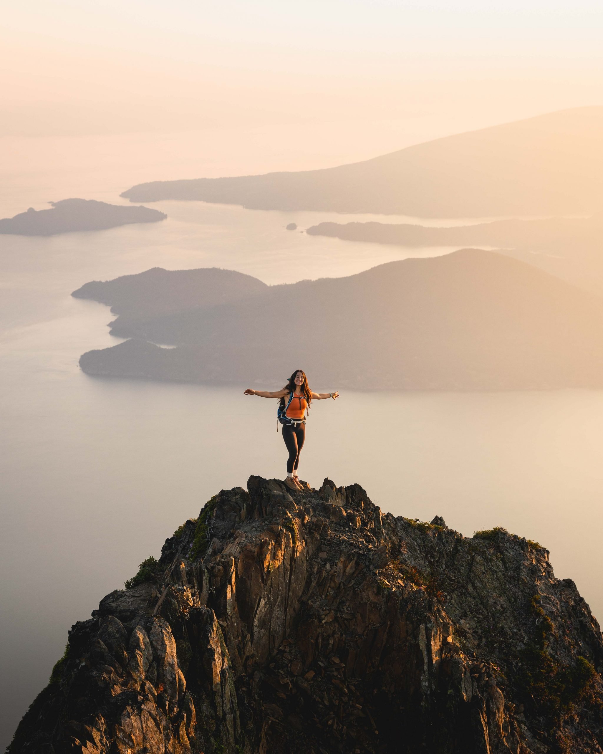
Photo Tip: Just like Saint Mark’s Summit, sunset is stunning here as it always sets along Howe Sound. It’s a long way down in the dark, though, so you need to be prepared.
8. Cheam Peak
This hike is in Chilliwack, which is in the opposite direction from the others in this post, but I had to include it here because it is one of my favorite hikes in BC!
The hardest part about Cheam Peak is getting to the trailhead.
The logging road to the trailhead is a rough road that can only be accessed with a true 4×4 vehicle. Do not take an SUV here. It will not get there. If you have a true 4×4 (or a friend who has one), you’re in luck!
You drive so high up the mountain that the effort you put into hiking seems so low for the views you get. 360 views of incredible mountains and the valley below. It usually takes me two hours to get up to the top.
Camping is not permitted on this trail.
Trail stats: Length: 9km (round trip) | Elevation Gain: 675m
See all info on the trail (including offline map): HERE


Photo Tip: If you’re lucky and conditions align, you could experience a cloud inversion here. I love the sunrise light here, so get ready for an early morning.
9. Pump Peak
If you’re looking for a hike that is close to Vancouver, Pump Peak is a great option. It’s on Seymour Mountain, which is only 30-45 minutes from Downtown Vancouver and offers epic views of the city and the surrounding mountain peaks.
The trail starts at the Mount Seymour Ski Resort, so there are loads of parking spots and easy access. The hike itself is moderately challenging, with steady elevation gain that’s manageable for most hikers and well worth the effort once you get above the treeline.
If you want to stretch your legs a bit more, you can continue on the trail to the Mount Seymour summit, which isn’t too much further.
Trail stats: Length: 6.9km (round trip) | Elevation gain: 454m
See all info on the trail (including offline map): HERE

Photo Tip: This is an amazing sunset spot! Don’t forget to bring a headlamp.
10. Mount Strachan
This is one of my favourite hikes in Vancouver and a must-do hike in British Columbia. It is stunning and isn’t as busy as the other trails on Cypress Mountain.
You get views of Howe Sound, the iconic Lions, and nearly a 360 ocean, mountain, and city view.
You can hike all the way up, but you can also get the Sky Chair(lift) up to the top of this peak, so it’s quite accessible. Be sure to check the times that it runs. I usually take it up and hike all the way down after sunset.
Every Thursday in August (2024), there is live music at the top of the trail. On these nights, the last ride down on the Sky Chair will be at 9:30pm, so you can enjoy the sunset without hiking down in the dark.
Trail stats: Length: 7.6km (round trip) | Elevation gain: 590m
See all info on the trail (including offline map): HERE
Photo Tip: This is one of the most incredible sunset spots! Don’t forget to bring a headlamp.
What an amazing list!! Thanks for the share!
Stoked you like it, Emma! Thanks for the comment.
Hi Julia,
Thanks for the comment and kind words. That jacket is from Helly Hanson and is called W KIRKWALL II Raincoat.
Angela ◡̈
These hikes are stunning! Thank you for sharing, I can’t wait for the border to open again 🙂
Hi there, I’ve been folowing your social media and I think your performance is amaizing, thanks for the inspiration.
Thank you so much for the support, Luis!
100% agree Panorama Ridge is the best in BC…followed pretty closely by Assiniboine. Awesome photos!
So happy you agree, Luke! Assiniboine is pretty incredible as well.
Hi! I love your blogs they are super inspiring! I was just wondering How early/late you left for the Mount Brunswick hike to catch the sunrise/sunset?
Thanks so much, Phoebe! I’d give myself around 3-3.5 hours to get to the top of Brunswick. I prefer sunset when hiking in the North Shore Mountains as the sun sets in front of you and it’s incredibly beautiful!
All places are so beautiful and thanks for to given opportunity to see your camp beautiful moments with our nature ….. Once again thanks Angela liguori
Hi Angela, thank you for all the information 🙂 I’ll be in vancouver for 1 year in 2023 so I pretend to do all this trails 🙂 I have a question regarding to the howe sound crest trail, I know is not on the list, but do you know if the camping sites are first come first serve? I check on the BC parks website, but there ir only backcountry’s campsites on Garibaldi and Joffre lake, not in Cypress Park. I’m a little confused with the difference between backcountry campsites and the normal ones 🙂 Thanks !!! I love your social media accounts
Hey Catalina, sorry for my delayed response but yay this is so exciting! Yes they are first-come-first-serve.
Hi Angela,
Can you recommend a good half day hike around Victoria that would be suitable to do in early November?
I love Goldstream Falls!
Hello Angela,
I love following your hiking adventures; you’re such an inspiration!
I’m from Washington State and am planning a trip to Vancouver, BC to hike the Wedgemount Lake trail. Could you kindly share how to get there? I’m checking the AllTrails app—is it the “Wedgemount Lake and Tupper Lake in Garibaldi Park? Do we need to book our trip there in advance? Also, do you have any cabin recommendations close to the trail so we won’t have to drive back the same day we hike?
Any insights and advice you can provide would be greatly appreciated.
Thank you!
Niezel
the Wedgemount Lake and Tupper Lake Alltrails page will work and take you to Wedgemount! Yes, you need to book a campsite before but they are first come first serve.
Awesome post!!
May I ask what camera or drone you use?
I use a Canon EOS R6 and I have the mini 🙂
An adventurous list of hikes like this in BC is amazing indeed, Angela, and I wish that Manitoba offered a similar list of hiking excursions to choose from. I’ll consider those recommendations for the next time I visit BC. Thanks.
Thank you for this amazing list! Can you please say where you were in Sooke that had the amazing cabin in the woods with the boardwalk leading out?
East Sooke Treehouse!