In British Columbia, the outdoors is at your doorstep and the options for backcountry campsites are seemingly endless. Here are 7 epic campsites close to Vancouver—that’ll get you started, at least!
If you need help with what to pack, check out my backpacking guide with a downloadable checklist. Packing can be overwhelming, so my aim is to make it easier for you.
Important: Leave No Trace
David Attenborough has said, “no one will protect what they don’t care about, and no one will care about what they have never experienced” and I couldn’t agree more. While there’s no doubt that social media, specifically Instagram, has led to certain outdoor spots being negatively impacted (overcrowded, vandalized, trashed, etc.), I choose to believe that social media, and the internet in general, can be a place where education and environmentalism can thrive. Online resources that include more information than just a geotag, like this blog post, allow for the outdoors to become more accessible, inclusive, and diverse. When people are immersed in the outdoors, they are more likely to become advocates for it—and hopefully inspire others to do the same.
When visiting these spots, following the Leave No Trace Principles are crucial to minimizing impacts when recreating outside. The principles are seven things that will help preserve the environment for generations to come. For example, it’s incredibly important to pack out what you pack in. This means taking all your garbage with you—including natural things like banana peels or apple cores. Even though they may decompose, it takes a long time (especially in colder temperatures) and it attracts animals. Check out the Leave No Trace Principles below:
- Plan Ahead & Prepare.
- Travel & Camp on Durable Surfaces.
- Dispose of Waste Properly.
- Leave What You Find.
- Minimize Campfire Impacts.
- Respect Wildlife.
- Be Considerate of Other Visitors.
If you’d like to learn more, which I hope that you do, take a couple of minutes to read this.
Ready for some of my favorite campsites close to Vancouver?
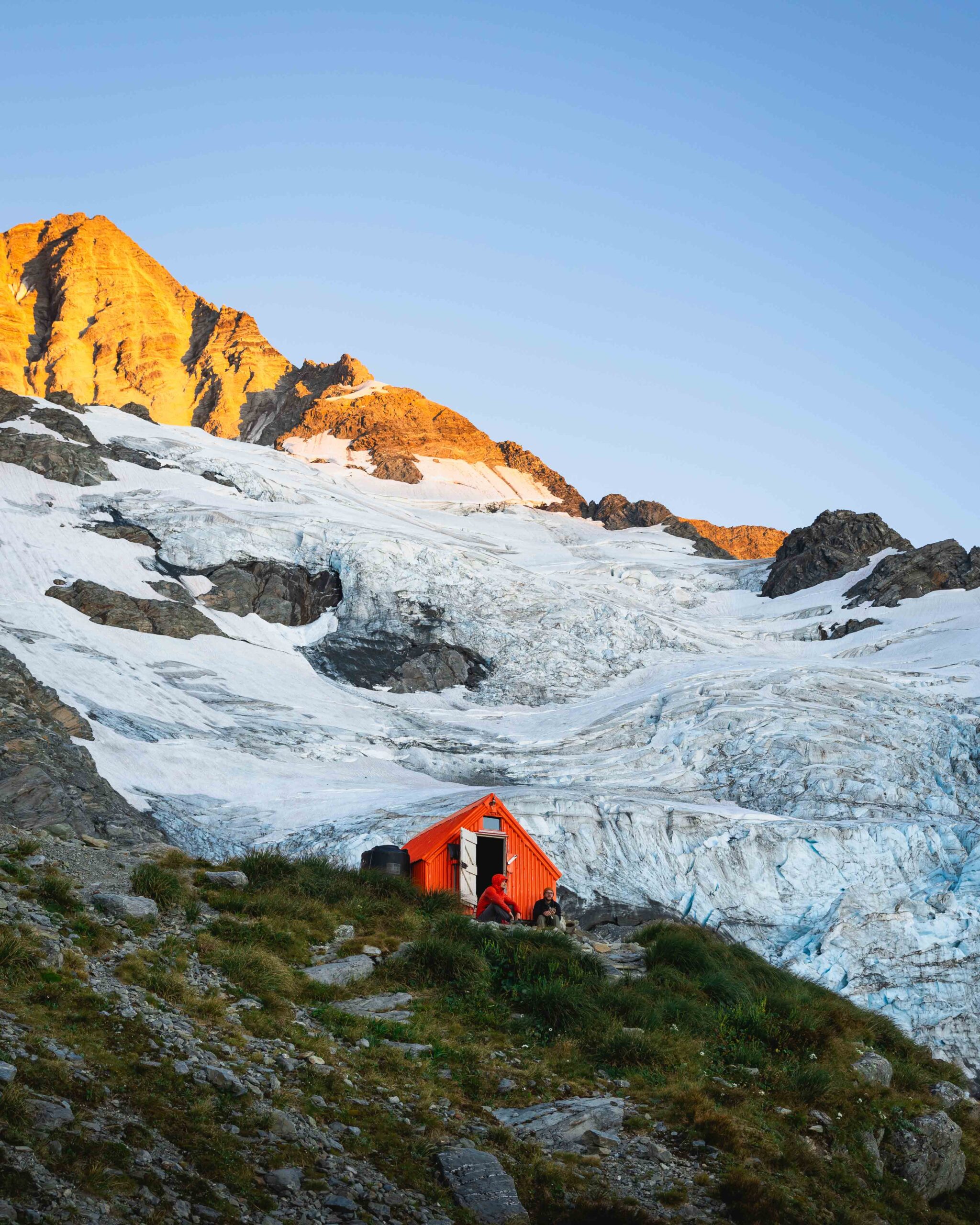
Wedgemount Lake
Length: 10.3km roundtrip | Elevation Gain: 1,200m | Difficulty: moderate


This is the epitome of a glacial lake that will take your breath away—literally and figuratively. It is a tough hike and takes me about 3-4 hours to get up to the lake with my overnight backpack on. The steepness of the hike is pretty relentless but once you reach the top you’ll be rewarded with epic views. I suggest getting an early start to the day so that you can pick your choice of tent pads as they, along with the shelter, are operated on a first-come, first-served basis. All campers must make a reservation and must have proof of the reservation. These fees go right back into maintaining the park. Having a screenshot of it on your phone is sufficient. Click here to make a reservation. There are pit toilets, bear caches, and great water sources available. This is one of my favorite campsites close to Vancouver!
Garibaldi Lake
Length: 18.2km roundtrip | Elevation Gain: 972m | Difficulty: moderate
Be warned, this trail is a busy one but still incredibly stunning. I suggest going up to Garibaldi Lake on a weekday if possible. The first 5km are switchbacks that are quite boring (it’s one of those hikes where it feels like it goes on forever) and relatively steep. Keep the conversation going, snacks out, water flowing and you’ll be there in no time.
This campsite is a great place to tackle Black Tusk or Panorama Ridge as a day hike. If you can’t snag a permit at the lake, I suggest booking at Taylor Meadows. Click here to make a reservation at either of the campsites. There are cooking shelters, picnic tables, pit toilets, food hanging areas and great water sources.
Mystic Beach
Length: 4km roundtrip | Elevation Gain: 65m | Difficulty: easy
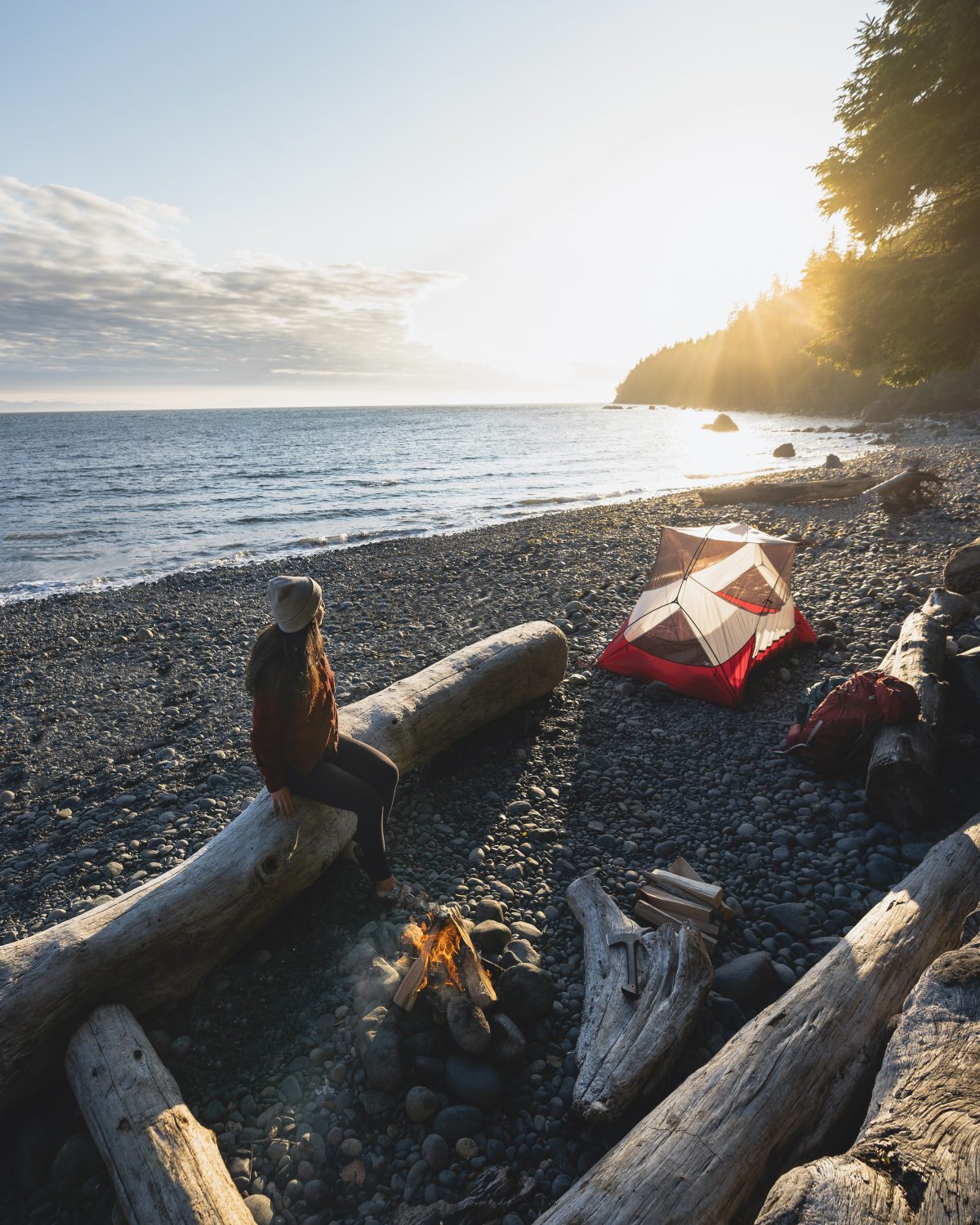
While Mystic Beach is completely different than the other glacial lakes and summits on this post, it’s just as epic. It’s situated along the shores of the Strait of Juan de Fuca and is a part of the Juan de Fuca Trail (which is a 47km multi-day backpacking trek). The hike is very easy and goes through a beautiful lush forest. Once at the beach, there’s a small waterfall that cascades from the sheer cliff above the beach and calming ocean views. For permits, you need cash to leave in an envelope at the trailhead (and bring a pen to fill out your info in a card provided).
Find a place to camp on the beach but along the treeline to ensure you’re far enough from the water because waking up the ocean water in your tent doesn’t sound fun (tides shouldn’t be overlooked). There are pit toilets but no food storage options, so you’ll need to bring either a bear bin or rope to hang your food. That I know of, there aren’t any freshwater sources apart from some questionable streams. I suggest packing your water with you! I know this is on Vancouver Island but it’s still one of my favorite campsites close to Vancouver.
Leading Peak
Length: 8km roundtrip | Elevation gain: 950m | Difficulty: moderate

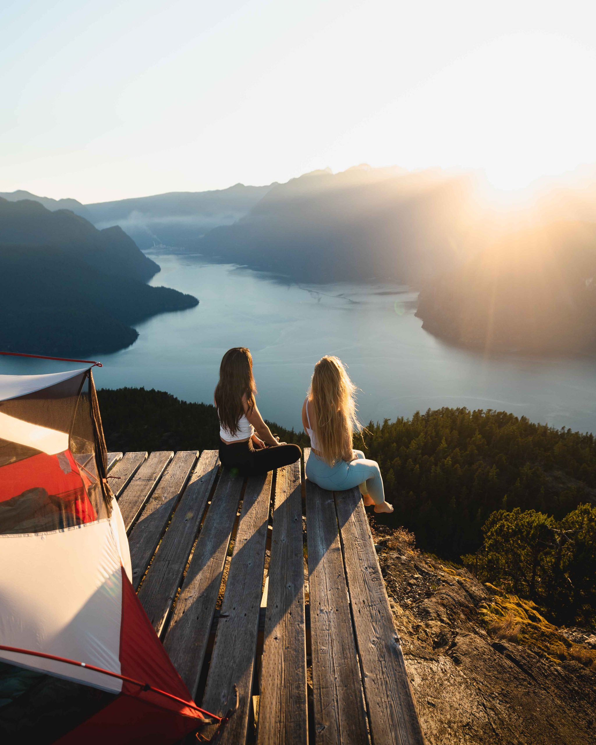
This backcountry spot on Anvil Island is a special one and is one of the most epic campsites close to Vancouver—but it accessing it has its challenges. To get here, you’ll need to find your way to Daybreak Point Bible Camp which is a 30-minute boat ride away from Horseshoe Bay. I booked a water taxi via Mercury Taxi and it costed $400CAD roundtrip. The next thing you’ll need to do is ensure you have permission to use the dock at Daybreak Point Bible Camp. This is essential as the trailhead is on their private property. Contact admin@anvilisland.ca via email and share the dates you’d like to use their dock (you just need permission to use their dock and trailhead as it’s on their property). I would also ask if there are any other groups also going to be up there on the dates you’re looking at. If there are more than two groups, I suggest finding a new day to go. Once you confirm your dates, consider donating to the camp in exchange for using their dock.
Once you take in the views of Howe Sound on the boat, you’ll need to meet the caretaker to be led through the property to the trailhead. From here, with overnight backpacks, you’ll be hiking for 3-4 hours and gaining quite a bit of elevation. There are sections that are basically straight up, with ropes and scrambling—which are all tricky with an overnight bag so please ensure you’re adequately experienced.
Do not, under no circumstances, stand up paddleboard or canoe to the island. It’s incredibly dangerous to cross the sound as conditions can change in a flash. I’ve been told kayaking is an option for those who are very experienced (but I for one wouldn’t take that route).
The trail is adequately marked with yellow markers, but I still used AllTrails to ensure I was on the correct path as there was some fallen debris that got me a bit turned around. The caretaker also mentioned keeping the wooden platform clear of any belongings from dusk to dawn in case a helicopter needed to land as it’s also a landing pad. Thankfully, I didn’t see any helicopters the night I was up there.
There are no toilets or bear caches up on Leading Peak, so you’ll need to bring a trowel and bear bin in order to minimize your impact and not attract animals. Lastly, in terms of water, there’s only a small lake (or glorified pond) mid-way on the hike. I suggest carrying up 3-4L of water with you and only drinking this lake water if absolutely necessary. I ended up drinking 2L of the lake water—filtering with a bottle and tablets. Having to carry this much water makes for a heavy backpack, so prepare yourself!
Elfin Lakes
Length: 20.1km | Elevation Gain: 821m | Route type: moderate
This is one of th emore popular campsites close to Vancouver, for good reason. I have day-hiked it, camped on the tent pads and in the hut many times and it doesn’t get old. I need to go back and get some new photos for you! My favorite thing about this campsite is that you wake up with mountains all around you and it’s great for a winter destination as well. It’s pretty magical. Click here to make a reservation. I suggest snagging a tent pad and then using the cooking shelters. There are pit toilets, food hanging areas, and great water sources.
Lake Lovely Water
Length: 13km | Elevation Gain: 1163m | Route type: difficult

Just like Leading Peak, this trailhead is a bit hard to reach. It isn’t accessible by land as the Squamish River is between the parking lot and the start of the trail. It’s common to take a helicopter up to the lake. The helicopter companies that have permission to fly into the park are Black Tusk Helicopter, Blackcomb Helicopters, Glacier Air, No Limits Helicopters, Sea To Sky Air, Seaair Seaplanes, or Whistler Air. The BC Parks website shares that “the trail to Lake Lovely Water is located on the west side of the Squamish River and can only be accessed by watercraft. The trailhead itself starts on private property and is unmarked for the first two kilometers. Access to the river from the east side is on the traditional lands of the Squamish First Nation and permission should be sought to cross. From what I’ve gathered, once you get permission, it’s an incredibly steep grind and can take anywhere from 5-8 hours to get up to the lake with overnight backpacks on.
Camping is only allowed on the tent pads, which are available on a first-come, first-served basis. Do not camp on the beach, meadows, or anywhere else. There are pit toilets and some food storage but I suggest bringing your own bear bin as it’s limited. Floaties for hanging out on the lake are not allowed.
Howe Sound Crest Trail
Length: 29km | Elevation Gain: approx 1,830m gain / 2,600m descent (if you start at Cypress) | Route type: difficult


I’ve hiked to several spots along this trail, but haven’t done the entire thing in one go. This summer, I’d like to scratch it off the bucketlist. For trail information, the great humans over at Outdoor Vancouver do an excellent job of breaking down what you need to know.
BC Parks shares the following information which is what you need to know if you want to hike and camp along this incredible trail. “Wilderness, backcountry or walk-in camping is allowed at higher elevations beyond the Alpine and Nordic ski areas and along the Howe Sound Crest Trail, but no facilities are provided. There are three preferred sites along the Howe Sound Crest trail.
- Magnesia Meadows (14.5 km from Cypress Mountain Resort );
- Brunswick Lake (19 km from Cypress Mountain Resort);
- Deeks Lake (22 km from Cypress Mountain Resort).
Tent pads or sites are not provided. Campers are encouraged to camp in cleared areas as to limit environmental impacts. The backcountry of Cypress Provincial Park can be rugged, and weather is often severe. Campers should be experienced in the backcountry and prepared for all weather conditions. Campfires are not permitted.“
Golden Ears
Length: 24km roundtrip | Elevation Gain: 1700m | Difficulty: hard


This is one of my favorite campsites close to Vancouver, but it’s also one of the most difficult. It’s first come first serve and there is only six wooden platforms to camp on, I believe. If all the platforms are taken make sure to only camp on a durable surface (dirt/rock), do not destroy any vegetation, and leave no trace, as always.
There was water at the campground coming down in a small stream, but that is not always the case. I recommend reading recent AllTrails reviews on the water situation because if there’s no water there you’ll need to fill up at a water source before Alder Flats Campsite.
You can find more information on AllTrails here.
All images were shot on my Canon EOS R and 15-35mm f2.8.
I love your content!! I found you on instagram, and let me tell you, all the photos you share with us are incredibly stunning and jaw-dropping! It makes me realize more and more what beautiful world we live in and how much there is to see and discover. Thank you for all your information and inspiration. Also, thank you for your recommendations on hiking gear, that is a very helpful resource!
Aw, Susana! Thank you! You’re too kind. I’m so happy to help 🙂
Wow, just wow. Incredible and impressive photos, so inspiring. Great job. I’ve done some the hikes already but you’ve motivated me to explore further, especially Wedgemount and the surrounding area.
Thank you. I’m so glad to hear that Mike. Wedgemount is one of my favorite spots in BC.
As always, your photos are absolutely incredible! I saw your IG post about “blog posts you may not know I have”… I looked at all those, then immediately also googled “Angela Liggs best campsites” and this popped up! The Canadian Rockies are one of my favorite places I’ve been so far but I’ve mostly hiked in Alberta and I’m wanting to do some hiking and backpacking in B.C.! I would be flying in to Vancouver. Would July 4 be a good time for most locations around there? Garibaldi Lake, Panorama Ridge, Wedgemount Lake… plus Joffre Lakes & maybe some others in Chilliwack. Thank you!
Thank you for the kind words, and for the comment Casey 🙂 Yes July will be good! There could be a little bit of snow on the high peaks to hike through, like on Panorama Ridge, but nothing to worry about.
Ok, WOW!! These photos are amazing. Is there much different between the seasons like summer / winter?
Thanks, Matt! Yes, it is super different in the winter. Our mountains get covered with snow.